The short version
To draw a map you need to know how far apart places are and where they sit on the globe. Surveyors measured one line very carefully, then used angles to work out every other distance by triangles. Finding your east-west position at sea needed something else: a clock that kept good time.
I always assumed old maps were drawn by walking around with a measuring tape.
You can't measure a country with a tape.
You measure one short line, and then use angles.
The trick: measure one line, then use angles
Walking every distance in a country would take forever and mistakes would build up. Surveyors used a trick called triangulation instead. If you know the length of one side of a triangle and two of its angles, you can work out the other two sides by calculation.
So a team measured one flat line very carefully, called the baseline. Then they stood at each end and measured the angle to a distant hill. That gave them a triangle. The far hill became the next point, and the next triangle was built on it, and so on across the country.
The surveyor's tools
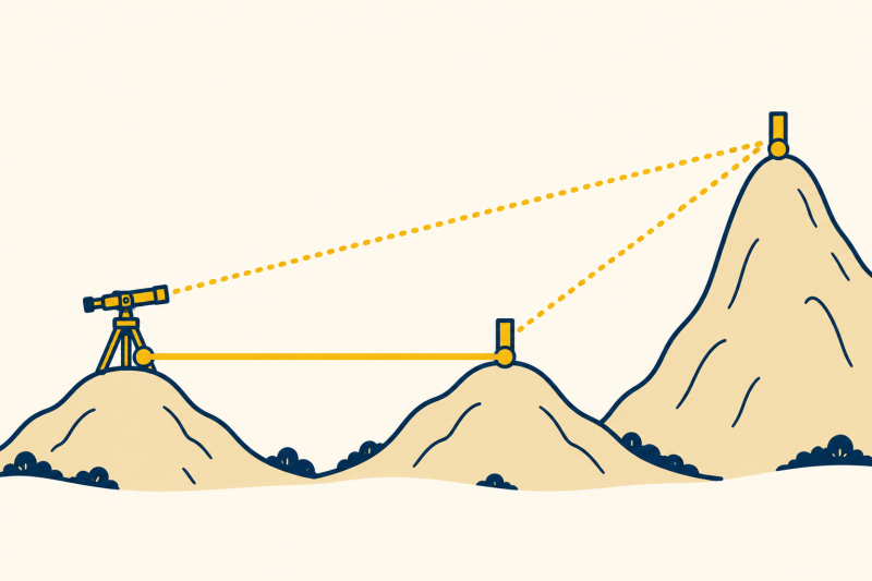
The angles were measured with a theodolite (thee-OD-uh-lite): a telescope on a stand that turns and tilts over marked circles. In 1784 a baseline of about five miles was measured across Hounslow Heath using glass rods, and a chain of triangles was then built outwards from it.
Weather mattered. Surveyors waited for clear days and sometimes lit lamps or flares on hilltops to be seen from far away.
The Ordnance Survey
The work led to the Ordnance Survey, founded in 1791 under the Board of Ordnance, partly because the government feared a French invasion and needed good maps of the south coast. Its first published map, of Kent, appeared in 1801. The survey grew into the map-making agency for the whole of Great Britain, and it still makes maps today.
Mapping Britain
- 1784 A baseline is measured across Hounslow Heath.
- 1791 The Ordnance Survey is founded.
- 1801 The first Ordnance Survey map, of Kent, is published.
- 1936 The Ordnance Survey starts building concrete triangulation pillars across Britain.
- 1990s Satellite positioning takes over most survey work.
The problem at sea: where am I east to west?
Ships could find their north-south position (latitude) from the height of the Sun or a star. East-west position (longitude) was harder. The Earth turns 15 degrees an hour, so if a navigator knew the time at home and the local time, the difference gave the longitude. For that you needed a clock that stayed accurate for weeks on a rolling ship, and pendulum clocks did not.
In 1714 Parliament offered a large prize for a solution. The clockmaker John Harrison spent decades building a series of sea clocks. His fourth, finished in 1759, was tested on a voyage to Jamaica that lasted about 80 days. Harrison's calculations put its error at only a few seconds after allowing for its steady daily rate, though the commissioners disputed that method of calculating the result.
A world map shows the real size of each country.
Every flat map stretches something. The Mercator map (1569) makes places near the poles look too big: Greenland looks as large as Africa, but Africa is about 14 times larger.
Why a flat map must lie
Imagine peeling an orange and pressing the peel flat. It tears or stretches. A map projection decides where to stretch it.
The Mercator map keeps compass directions true, so a ship could steer a straight line on it, which is why sailors liked it. Other maps keep sizes true but bend shapes. Each choice is a trade-off, and no flat map keeps everything right.
Sources: Ordnance Survey, History and History of the trig pillar; Royal Museums Greenwich, Harrison's clocks and the longitude problem. Early dates are approximate.
Key takeaways
- Surveyors measure one line, then use angles.
- Triangles give every other distance.
- A theodolite measures angles accurately.
- Longitude needs an accurate clock.
- Every flat map distorts something.
Now you know.
Maps were built from triangles.
Longitude came from a clock.
And every flat map has to stretch the world.
Last reviewed 3 Nov 2026
Where next?
More in History
-
Read
 History
Dating the past
How scientists work out the age of bones, wood and rocks using radiocarbon dating, tree rings and rock…
-
Read
 History
Roman roads
How the Romans surveyed and built long straight roads, with layers of stone, a curved surface and ditches…
-
Read
 History
The calendar
Why a year needs leap days, how the Julian and Gregorian calendars differ, why month names look odd, and how…